Showing posts with label Newfoundland. Show all posts

Thursday, May 31, 2012

Cape Spear Light

Cape Spear in Newfoundland is considered the most eastern point in North America.   At night you can look across the bay and see the lights of the capital city,  St. John.


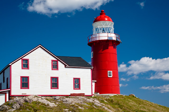
The tall lighthouse on Cape Spear was built in 1955 and uses the dioptric lens from the original.


The original lighthouse began operation in 1836 in this small square building.  It is the oldest surviving lighthouse in Newfoundland and Labrador. A stone light tower was built inside to support the lantern room in 1850 after a storm lifted one side of the lighthouse several inches off the foundation. The original light came from a lighthouse from Scotland and used seven Argand burners with curved reflectors. The lamps and reflectors were on a metal frame which rotated to produce 17-second flash of light followed by 43 seconds of darkness.   The first fuel was sperm whale oil and seal oil, acetylene in 1916 and eventually electricity in 1930.  The original curved reflectors were replaced by a dioptric lens system in 1912.  A foghorn was added in 1878.


This was the second lighthouse in Newfoundland.  The first light was placed at Fort Amherst, the entrance to St. John's harbor in 1810.

Today, the interior has been restored to the period of 1839 and is open to the public, giving visitors a glimpse of the life of a light keeper.  Generations of the Cantwell family lived and worked at Cape Spear for over 150 years, maintaining this vital light for the mariners. A detailed history of the Cantwell family and the Cape Spear Light can be found at the Lighthouse Friends website.


I loved the parlor. I can really image the lightkeeper and his family spending time here.


The flag room housed the marine signal flags, an easy and universal way for ships and lighthouses to communicate important messages. 


Cape Spear is also a great place to watch for birds and whales.  During the summer, it is possible to see shearwaters such as Manx shearwater, Sooty shearwater, and Greater shearwater which are usually only seen far out at sea.  Other bird species such as murres, razorbills, skuas, and jaegers may be seen as well. While the humpback whale is the most commonly sighted whale, minke and fin whales are also seen.  Other marine mammals such as beaked dolphins, porpoises, harbor seals, and otters have also been spotted.

Tuesday, February 07, 2012

Atlantic Puffins

At Bull's Bay, we checked in at Mullowney's Puffin and Whale Tours.  We were the only ones there for the next cruise, but they agreed to take us!  Since our time in Newfoundland was limited, it was such a blessing to get to do the puffin tour without having to come back the next day.

I've been fascinated with puffins since I saw tufted puffins along the Oregon coast.

Off the Newfoundland coast on rocky islands, Atlantic puffins nest in small burrows surrounded by grass.  One parent stands guard.


Puffins nest as far south as Maine and on islands across the North Atlantic from Iceland to Ireland and from northern France to Norway.

Excellent fishers, they float in the water until our boat startles them.  Puffins are fast flyers.  If I could go back, I would use a faster shutterspeed - 1/250 sec wasn't fast enough! They are challenging to photograph because you must lock on for focus before they startle into flight. 


Puffins can carry as many as 30 small fish to bring back to the nest, but usually only carry up to 10.

Atlantic Puffins can live to be 30 years old. They choose their life mate when 3 to 5 years old.  They only come to land to breed and raise their chicks, surviving well far out into the ocean.  Strong swimmers they can dive to 200 feet. In flight they can fly up to 55 miles per hour.

Their greatest enemies are the great black-backed gull which can capture a puffin in flight or on the ground and herring gulls who steal the fish and pull chicks and eggs from the nests.

Saturday, September 03, 2011

Cape Pine Light


Cape Pine Light is at the southern most point of Newfoundland.  Located along the scenic Irish Loop, it is a 5 mile gravel road drive off the main road to get there, but we were rewarded by seeing the only caribou on this trip.  With gray cloudy skies, shooting for High Dynamic Range (HDR) was a must.  I shot multiple exposures and hoped that post processing would give me a useable image.  I used Photoshop to merge the images and then Photomatix to do the tone mapping.  I then used Topaz products to brighten the reds and make it a more vibrant image.

Cape Pine, built in 1851, is still a working lighthouse.  It flashes white every 5 seconds and is visible for 16 nautical miles.  Michigan Tech has been using it as a pollution research station with funding from the National Oceanic and Atmospheric Administration and the National Science Foundation.

Just north of Cape Pine Line, we spent the night in Trepassey at a lovely hotel, the Trepassey Motel and Restaurant,  that included a dining room with views of the sea.  With friendly owners, good food and comfortable rooms, this would be a good place to spend several days and spend more time along this lovely coastline.

Friday, September 02, 2011

Ferryland Light


One of my favorite memories from my Newfoundland trip was my hike up to the Ferryland Lighthouse. While it was an uphill hike of 2 kilometers, it was pleasant.


But the views at the top were amazing. I had to walk alone because Henry's knee was not up to the 25 minute walk. When I got to the top, there were so many people who were taking advantage of the picnic lunches. It was hard to get a photo of the lighthouse without people in the frame. There were couples and families scattered on the green carpet of grass eating what looked to be wonderful picnic lunches. There were kids romping and exploring. A minke whale even surfaced near the shore close enough to hear the blow.

Ferryland Light was built in 1870 and manned until it was automated in 1970. After being abandoned for about 20 years, Lighthouse Picnics began serving picnic lunches and also began restoring the lighthouse. Today, the menu boasts food made fresh each day - molasses oatmeal bread, fresh made scones, orzo and fresh mint salad, and freshly squeezed lemonade. Coffee and specialty teas add to the charm. They use local and organic products as much as possible. The cold water shrimp, salmon and crab are harvested from Newfoundland waters.

The town of Ferryland is also interesting to visit. The Colony of Avalon was founded in 1621 by George Calvert who later became Lord Baltimore. The settlement ruins were undisturbed for centuries, but are now being excavated. Archaeologists have found over a million artifacts. An Interpretation Center and a walking tour give you a sense of what life in the 1600's was like.

Ferryland is about an hour's drive south of St. John.

Tuesday, August 24, 2010

Gros Morne National Park

August 20, 2009

We enterted Gros Morne National Park from the north. So our first views were of these spectacular mountains and beautiful glacier carved fjord at Western Pond.  Sadly, we arrived too late in the day to do the BonTour's Western Pond Boat Tour.  It is a 1.8 mile walk to get to the boats.  The tour lasts 2 hours and costs $52.00 for adults and $25.00 for kids.  It is on my to do list for the next time we make it to Newfoundland.  BonTours also has boat tours of Bonne Bay.


The scenic town of Rocky Harbor is the place to stay to enjoy Gros Marne - good hotels and restaurants as well as beautiful ocean views. Lobster Cove Head Lighthouse drew me because I love lighthouses.


The rocky beaches west of Rocky Harbor made a great sunset vantage point.


The next morning we headed south and drove through the mountains of Gros Morne.


We knew we hadn't given this park the time it deserved, but we got a wonderful taste of the beauty and wonder here.

Tuesday, August 17, 2010

The Arches Provincial Park

August 20, 2009

As we headed south from St. Anthony, we came across this small provincial park.  Lighting wasn't great with the cloud covered, sunless sky. I shot for HDR hoping I could create a good memory photo since I knew we couldn't stay around this location long enough to get a sunrise or sunset setting. 


While the main attraction is this wonderful set of sea arches, the rest of the beach is also lovely.  


These wind sculpted, dead trees tell the story of strong winds and a harsh climate.

Friday, August 06, 2010

Newfoundland's Crown Land


I was fascinated by the small gardens that we saw along the roads in northern Newfoundland. These gardens were not next to someone's house our field, rather they were right next to the road. When I asked local people, it turns out that the best soil for gardens is where soil was brought in to build the roads. This land is "crown land," land owned by federal or provincial governments. According to the Canadian Encyclopedia only 11% of Canada's land is in private hands, 41% is federal crown land and 48% is provincial crown land. Newfoundland has the highest percentage of crown land with 95% being owned by the government. Among the permitted uses in northern Newfoundland are these gardens that provide needed produce during the short growing season.


Picturesque and well kept, the primary crop seems to be potatoes, but some of the larger plots had a mix of garden vegetables. In a place where it is not easy to get fresh produce, these gardens are an important part of the food supply here.

There also seems to be a certain amount of wood gathering permitted.

I suspect that it takes a lot of hard work to live in northern Newfoundland, but I really appreciate a lifestyle that manages to find ways to live off the land using the resources available-fish, wood, native berries, and these lovely gardens.

Wednesday, August 04, 2010

Whale Watching at St. Anthony, Newfoundland

August 20, 2009

Being fascinated by whales and marine mammals, I take every whale watching tour I can find. In St. Anthony, Newfoundland, Northland Discovery Boat Tours offers iceberg, whale, and seabird tours. We were too late in the season for icebergs, but we headed out on a foggy, misty morning. As we headed out to sea, there was Newfie music playing over the loud speaker - lovely, jaunty Irish sounding melodies. As we left the harbor and headed out to sea, these stark, rocky cliffs were amazingly beautiful.


As we reached the choppy open water, we began to watch for spouts.


Whale watching is exciting to me even when it is just watching those sleek bodies gracefully surface and submerge again. Sometimes you are lucky enough to see the tail as they begin their deep dive.


We were seeing humpback whales and they were consistent with their surfacing and deep dive timing. So we got good regular sightings.

We also got to see Atlantic white beaked dolphins. Whales come up and surface with a slow rhythmic pattern, giving you time to capture the experience with your camera. Dolphins zip right past the boat making photographs more a matter of luck than skill.


What with the gray day, low lighting, I didn't expect great shots, but I couldn't resist trying to catch these playful dolphins.


It continued gray and foggy even as we returned past theSt. Anthony Harbor Lighthouse and into the harbor. There's a great restaurant at the lighthouse, the Lightkeeper's Cafe, and a great view. We found the cafe and lighthouse area a great place to end our days at St. Anthony, Newfoundland.


I am grateful I don't get seasick easily, because it was a choppy day on the water. But even with gray skies, swells, and seasick visitors next to me, it was still a great way to spend the morning!

Thursday, July 29, 2010

L'Anse aux Meadows National Historic Site

Time to get back to finishing my blogs about our Canada trip last year.

We entered Newfoundland from the North via a short ferry from Blanc Sablon, Quebec to St. Barbe, Newfoundland. We headed to St. Anthony to get our accomodations. We had learned about L'Anse aux Meadows from the Americans we met at Manic 5. The site of the Viking landing in North America, it is both a National Historic Site in Canada and a UNESCO World Heritage Site. Naturally, it was on my must see list.

It was a gray, rainy day for our visit and lighting didn't look promising., so I left my good camera in the car and set out to enjoy my day in spite of the weather. These pictures are courtesy of Henry, as he carried his smaller camera with him on our tour.

As you begin your guided walk through the excavated mounds, you pass through this amazing sculpture, The Meeting of Two Worlds. Designed to celebrate the meeting of the European culture with the Aboriginal people who were Newfoundlands first peoples.


The site is grass covered and there are still a few houses in the distance along the sea that will be removed as the original owners have been allowed to remain for their lifetimes. Ultimately the goal is for this site to look much as it did when the Vikings arrived.


We took the guided tour of the site and were so fortunate that our guide was intimately involved - his grandfather had led archaeoloists Helge Ingstad and his wife, Anne Stine Ingstad to a mound on his farm that turned out to be Leif Erickson's Vinland colony. This 11th-century settlement is the first European presence in North America. The excavated ruins are similar to the wood framed peat-turf buildings found in Norse Greenland and Iceland. In some ways the construction is like the sod houses originally built by settlers in the Great Plains - wood timbers with blocks of the peat bog creating thick walls with a sod roof.


Time to get back to finishing my blogs about our Canada trip last year.

This long house is still under construction or they are redoing the peat sod roof, but it gives you an idea of the size and construction of these amazing buildings.


The Vikings only stayed here somewhere between three and ten years, but the archaeologists found a soapstone spindle whorl, a bronze-ringed pin process and toerh iron, bronze, stone, and bone items. I learned that you can get iron ore from peat bogs and the Vikings made nails from the iron found in the peat.

We were lucky to be visiting on a day when public school teachers were visiting for training - so there were hands on demonstrations of making nails, knitting with one needle, and story telling. They have recreated the long houses and the site is a living history with people dressed up as Vikings and showing how the people lived and retelling the ancient stories.

As the day was cold and rainy, I enjoyed sitting by the fire and soaking in the stories and the ambiance of life in the 990-1030 AD time period.

Wednesday, August 19, 2009

Trying to catch up with Tweets & Blog

I had intended to keep up with my blog as I went on this trip, but at the WorldCon in Montreal, my intermittent computer problem decided to become a full time problem - it is hard to work on a computer when the computer works but the screen doesn't. So, Henry and I have been sharing the computer. Another issue - internet access has not been something we can count on. I've done some tweets - but even they do not show up as a steady stream - I compose them as we go using the Bird House app on my I-phone and then post a stream of tweets all at one time - not a perfect solution.

When we get home, I'll come back and revisit the highlights of this trip with blogs with photos, but here is a synopsis.

We headed north from Amarillo - going through Saskatchewan, Manitoba, and Ontario on our way to Montreal. After the WorldCon, we continued east through Quebec Province following the St. Lawrence River. We did whale watching at Baie St. Catherine - seeing Beluga whales, minke whales and humpback whales. We continued up the St. Laurence to Baie Decomeau heading north to Labrador. We saw the amazing hydroelectric system that Canada has built - including the amazing dam at Manic 5. At Churchhill Falls in Labrador there is another amazing underground hydroelectric plant utilizing the Churchill River.

Continuing southeast we ended up at Happy Valley/Goose Bay to take the Ferry to Cartwright. From Cartwright we continued south to the coastal fishing villages. We took the ferry from Blanc Sablon to St. Barbe, Newfunland. We have spent two nights in St. Anthony. Today we visited the Viking site- proof that the Vikings visited North America in 1000 A.D. We are hoping to go whale watching/iceburg watching tomorrow. That excursion was cancelled today because the wind was coming from the wrong direction making the sea too choppy for them to want to do the trip.

Last but not least, we have noted that Hurricane Bill has formed in the Atlantic. It has grown to a category 4 storm. Now you may be asking - why would the Meltons worry about a hurricane when they are so far north? Well . . . last time we were planning to visit Nova Scotia and take the ferry across the Bay of Fundy - we were told at the campground in a nice Scottish brogue, "Well, we had beautiful weather today, but tomorrow a hurricane is coming in." When we checked our satellite internet, sure enough a hurricane was coming in - and a Category 2 at that! The current storm path for Hurricane Bill has it crossing Nova Scotia and Newfoundland! We are not in the RV and we have weathered a hurricane at this point . . . but . . . I sure hope that Bill stays in the Atlantic and doesn't hit land ANYWHERE!!!! We are likely to still be in Newfoundland needing to cross a ferry about the time, it would likely decide to hit . . . so . . . we'll keep on with our itinerary and hope for the best. But I do find it strange that the two times I've been in this part of the world, that a hurricane has been part of the story!